


Top Hiking Trails in Chamonix Summer
Chamonix Mont Blanc valley
Top summer hikes in Chamonix
Summer is undoubtedly the best season for exploring the Chamonix Valley on foot. From June to September, the mountain trails reveal their full beauty: flowery alpine pastures, high-altitude lakes, breathtaking panoramas of the Mont Blanc massif, and mountain huts perched in the heart of unspoiled nature. It's not uncommon to spot ibex in the Aiguilles Rouges nature reserve.
Thanks to the ski lifts and an extensive network of marked trails, everyone can find a hike suited to their level, from a simple family stroll to sporty routes offering spectacular views of glaciers and the highest peaks of the Alps.
Even in summer, the mountains remain a demanding environment. It is important to check the weather forecast before each outing, to bring enough water, good shoes, and clothing suitable for temperature variations. Some routes may also have technical sections or be subject to temporary restrictions.
To prepare for your hikes, feel free to consult the updated information from the Chamonix Guides Company, La Chamoniarde (visit their website here) , as well as the numerous guides and maps available in our apartments. I also recommend using the free Géoportail app to easily locate yourself on the trails. For trails near Vallorcine, you can also contact the Vallorcine Tourist Office; their team is helpful and offers excellent advice.
To help you organize your summer stay, I have selected the most beautiful hikes to do in the Chamonix valley and around Vallorcine (I have limited myself to about 25 routes, but with very different levels), with my local advice to fully enjoy your stay.You will have difficulty making your choices...
Don't forget to check out my article dedicated to activities in the Chamonix valley (and surroundings): I present HERE: the 20 best activities with my local tips!
By staying in Vallorcine in my apartments (here), you benefit from privileged access to the most beautiful trails in the valley while enjoying a calm and preserved environment, far from the hustle and bustle of the center of Chamonix.
Vallorcine - Argentière - Swiss border area:
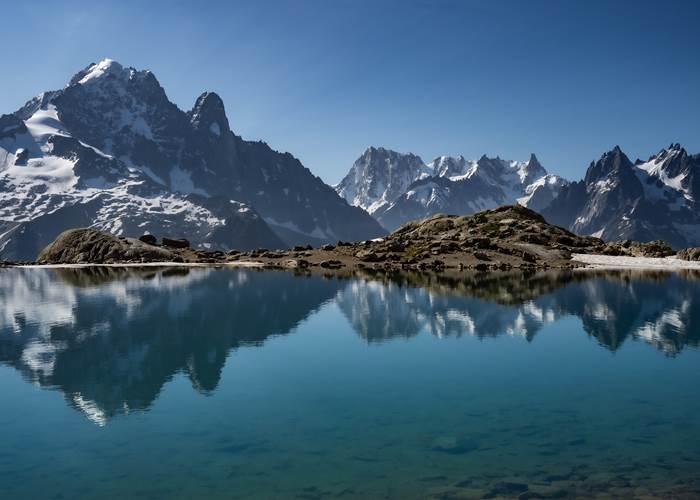
- Lac Blanc 💙
Lac Blanc is the iconic hike in the Chamonix valley. Its exceptional panoramic views of the Mont Blanc massif and its reflections in the lake's waters make it one of the most photographed sites in the Alps. A must-see for any first-time visit to the valley.
I recommend leaving early to avoid the crowds (in July/August).
There are many variations, but I much prefer starting at the Col des Montets. You'll be in ibex country.
Difficulty level: Intermediate (Flégère cable car) to difficult depending on the variations
Distance: 7 km
Duration: 4 to 6 hours
Elevation gain: 500 m to 1200 m
Altitude: 2,352 m
- Chéserys Lakes 💙
Located just below Lac Blanc, the Lacs des Chéserys offer an enchanting setting with several small high-altitude lakes surrounded by alpine meadows. Numerous routes are possible. I recommend starting from the Col des Montets! It's common to encounter ibex.I love this hike.
Difficulty level: Intermediate (Flégère cable car) to difficult
Distance: 6 km
Duration: 3 to 5 hours
Elevation gain: 450 m to 1000 m
Altitude: 2,211 m
- The Aiguillette d'Argentière ⭐
The trail starts near the Trélechamp-le-Haut car park. It passes along the side of a large slab of rock, then continues to Plan de la Grange. Entering a beautiful larch forest, it climbs diagonally to 1710m. You are now in the Aiguilles Rouges nature reserve (dogs prohibited), and with luck you might spot some ibex.
Difficulty level: Intermediate
Distance: 8 km
Round trip duration: 3 hours
Elevation gain/loss: +500 m / -500 m
Altitude: from 1420 m to 1900 m
- Les Chalets de Loriaz – Vallorcine ⭐
An unmissable hike in the Chamonix valley in all seasons
Starting from Vallorcine, this magnificent loop takes you to the alpine chalets of Loriaz (2020 m), nestled in the heart of the Aiguilles Rouges massif. Start: Couteray, return: Couteray
Upon arrival? A breathtaking panorama facing the Mont Blanc massif… a view you never tire of. A delicious break at the Loriaz refuge (remember to check opening times) is the perfect reward after the effort. I highly recommend it!
Difficulty level: Difficult
Round trip duration: 4 hours (depending on snow conditions and difficulty level)
Elevation gain: +700 m
Altitude: from 1200 m to 1900 m
- La Pierre à Bérard Vallorcine👍
A very pleasant hike along the Eau de Bérard, partly through larch woods, bordering the Vallon de Bérard Nature Reserve. At the end: a mountain refuge with food available. The trail starts at the hamlet of Le Buet in Vallorcine and leads to the Refuge de la Pierre à Bérard (highly recommended!).
Difficulty level: Difficult
Distance: 10 km
Round trip duration: 3 hours 30 minutes
Elevation gain/loss: +600 m / -600 m
Altitude: from 1300 m to 1900 m
- Granges Vallorcine Loop:
A good alternative if you don't have the energy to hike to the Loriaz chalets. My personal favorite, with a magnificent view of the Aiguille Verte from the hamlet of Les Granges. Start in Couteray towards the hamlet of Les Granges, return via the Bérard valley/Bérard waterfall.
Difficulty level: Easy (valley bottom)
Distance: 5 km
One-way journey time: 3 hours
Elevation gain:+200 m
Altitude: 1300 meters to 1450 meters
- Aiguillette des Posettes and Tête de Balme⭐
This panoramic hike is one of the most beautiful accessible from Vallorcine. From its summit, the 360° view extends to Mont Blanc, the Aiguilles Rouges, the Buet, and the Swiss mountains. A true natural viewpoint. In summer, access is via the cable cars from Le Tour or Vallorcine.
Balme Alpine Pastures: excellent refreshment stand, I recommend it!
Difficulty level: Intermediate (starting from the top of the cable cars)
Distance: 6 km to 8 km
Duration: 3 to 4 hours
Elevation gain: 450 m to 650 m
Altitude: 2,201 m
- Stroll around the main town of Vallorcine ⛪
A lovely historical walk to immerse yourself in the heart of the hamlets of Vallorcine. Loop from the church of Vallorcine to the hamlet of Buet by taking the old stagecoach road (many paths to discover along the railway or the river).
Difficulty level: easy (valley bottom)
Distance: 4.5 km
One-way journey time: 2 hours
Elevation gain: +90 m
Altitude: 1300 meters
- Bérard Waterfall ⭐
A lovely walk starting from the hamlet of Buet, then an impressive Bérard waterfall, well-equipped with a footbridge, a colorful refreshment stand with homemade products and a curious cave at Farinet, return via Le Couteray.
Take a break at the refreshment stand, it's excellent!
Difficulty level: Easy
Distance: 4 km
Duration: 1 hour 30 minutes to 2 hours
Elevation gain: 250 m
Altitude: 1,550 m
- Albert 1er Refuge 🧊
Starting from the village of Le Tour, this hike immerses walkers in the atmosphere of the high mountains. The trail offers remarkable views of the Tour Glacier and leads to a legendary mountain refuge frequented by climbers. It's possible to take the Le Tour gondola followed by a chairlift.
Some sections are tricky, so be careful if you are prone to vertigo!
Difficulty level: Difficult to athletic (departure from the cable car)
Distance: 11 km
Duration: 5 to 6 hours
Elevation gain: 850 m
Altitude: 2,702 m
- Small south-facing balcony: Argentière-Les Tines 🏔️
This trail runs through the Chamonix valley, it allows you to reach Argentière aux Tines and offers beautiful views of the valley and the Mont Blanc range at every moment.
Return possible via the Mont Blanc Express train
Difficulty level: easy (valley bottom)
Distance: 4 km
One-way journey time: 1 hour 15 minutes
Elevation gain/loss: +90 m / -200 m
Altitude: from 1247 m to 1290 m
- The Péclerey Mountain ❤️
I absolutely loved this magnificent, little-known hike, with views of the Mont Blanc massif and the Tour glacier. The hike starts from the hamlet of Le Planet and returns via Le Tour.
Difficulty level: Intermediate
Distance: 8 km
Duration: 3 hours 30 minutes
Elevation gain: 600 m
Altitude: 2000 m (max)
- Lake Émosson: Dinosaur tracks 💙
Located in Switzerland, a few kilometers from Vallorcine, Lake Émosson captivates visitors with its turquoise waters and magnificent surroundings. This excursion also offers the opportunity to discover the famous dinosaur footprints, over 240 million years old.
A site not to be missed! I recommend it (possibility of zip-lining at the Emosson dam).
Difficulty level: Intermediate
Distance: 10 km
Duration: 5 hours
Elevation gain: 500 m
Altitude: 2400 m
- The Trient Bisse 👨👩👧👦
An easy and beautiful hike for the whole family. Head towards Martigny in Switzerland until you reach the Col de la Forclaz parking area. Take the Bisse de Trient path to the Trient Glacier refreshment stand.
A lovely, easy family hike.
Difficulty level: easy
Distance: 6.5 km
Round trip duration: 2 hours
Elevation gain: +100 m
Altitude: 1550 m
Chamonix area:
- The Montenvers - Plan de l'Aiguille crossing ❤️
A classic route in the valley with no particular difficulties. Take the little train from Montenvers with a ticket valid for the descent via the Plan de l'Aiguille cable car (I slightly prefer going in that direction). This hike is a must for me; a break at the Montenvers refuge is essential, and the passage by the Signal Forbes is breathtaking. Magnificent views of the Mont Blanc massif towards Plan de l'Aiguille. The Plan de l'Aiguille refuge has a superb refreshment stand with delicious blueberry tarts.
Difficulty level: Intermediate
Distance: 6-7 km
Duration: 3 hours
Elevation gain: 500 m
Altitude: 2000 m
- Cornu Lake and the Black Lakes⭐
Nestled in a spectacular rocky landscape in the heart of the Aiguilles Rouges, Lac Cornu is a popular destination for experienced hikers. Its wild surroundings and views of the Mont Blanc massif make the trip worthwhile. I often saw ibex; it's even better if you continue on to the Lacs Noirs.
Several routes are possible (starting from the Planpraz or Flégère cable cars): refer to hiking guides. The section is tricky if you are coming from the Flégère cable car.
Difficulty level: Difficult - Sporty
Distance: 8 km (several variations)
Duration: 5 hours
Elevation gain: 800 m (several variations)
Altitude: 2,400 m
- Le Brévent 🚠
Directly overlooking Chamonix, the Brévent is considered one of the most beautiful viewpoints in the Mont Blanc massif. From its summit, the panorama of the glaciers and the great peaks is simply spectacular. Several variations are possible, with return routes via Les Houches.
Difficulty level: Intermediate to difficult
Distance: 8 km
Duration: 4 to 5 hours
Elevation gain: 600 m
Altitude: 2,525 m
- Forbes Signal 🚋
Accessible from the Montenvers train, this easy hike offers magnificent views of the Mer de Glace glacier, the Drus peaks, and the Grandes Jorasses mountains. An excellent choice for enjoying a breathtaking panorama without excessive effort.
Difficulty level: Easy
Distance: 5 km
Duration: 2 hours 30 minutes
Elevation gain: 250 m
Altitude: 2,198 m
- Large South-facing balcony 🏔️
The Grand Balcon Sud is an exceptional panoramic route overlooking the entire Chamonix valley. The trail offers continuous views of the Mont Blanc massif and connects several iconic areas of the valley. It starts at the top of the Flégère gondola and ends at the Planpraz gondola (book tickets accordingly).
Difficulty level: Intermediate
Distance: 8 km
Duration: 4 hours
Elevation gain: 300 m
Altitude: Between 1,800 m and 2,200 m
- Small southern balcony: Les Tines – Les Gaillands Chamonix
Panoramic balcony with minimal elevation gain. Numerous viewpoints overlooking the Mont Blanc massif. Return possible via the Mont Blanc Express train – Pélerins station.
Difficulty level: easy (valley bottom)
Distance: 8 km
One-way journey time: 2 hours 45 minutes
Elevation gain/loss: +190 m / -250 m
Altitude: from 1080 m to 1270 m
- The Hat Chalet 👌
Viewpoint overlooking the Mer de Glace, the Arveyron Gorges, the Aiguilles and the Chamonix Valley. Departure from the SNCF train station in Les Tines (other routes are possible from Les Bois or Le Lavancher).
A wonderful and delightful time at the Chapeau refreshment stand (open depending on the weather), I highly recommend it!
Difficulty level: Medium (balcony view)
Distance: 5 km
Round trip duration: 2 hours 30 minutes
Elevation gain/loss: +500 m / -500 m
Altitude: from 1050 m to 1600 m
- Rochers des Mottets 👍
Stunning viewpoint overlooking the Aiguilles des Drus. Amazing site of red rocks. View of the Mer de Glace glacier. Starting point: Les Bois hamlet (or Chamonix Les Planards).
Superb refreshment stand with light meals: I recommend it!
Difficulty level: Medium (balcony)
Distance: 8 km
Round trip duration: 3 hours
Elevation gain/loss: +600 m / -600 m
Altitude: from 1050 m to 1650 m
- Jonction Hike 🧊
A classic spot in the Chamonix valley. Breathtaking views of the Bossons and Taconnaz glaciers. Reserved for expert hikers with tricky sections and steep elevation changes.
Difficulty level: Very difficult
Distance: 13 km
Round trip duration: 7 to 8 hours
Elevation gain: 1400 m
Altitude: 2,589 m
Houches/Servoz area:
- Bel Lachat Refuge, Aiguillette des Houches 👍
A superb hike with a significant elevation gain to the Bel Lachat refuge. After traversing the wild meadows of the Carlaveyron nature reserve, a breathtaking 360° view unfolds before you, offering stunning vistas of the Aiguillette des Houches, facing Mont Blanc. The hike starts from the Merlet Animal Park parking area, heads towards the Bel Lachat refuge, and returns via the Chailloux chalets. It's also possible to reach the Aiguillette des Houches from the Brévent gondola lift.
Difficulty level: difficult
Distance: 9 km
Duration: 5 hours 30 minutes
Elevation gain/loss: +800 m / -800 m
Altitude: from 1500 m to 2300 meters
- The chalets of Charousse, Les Houches 🏚️
Magnificent views of Mont Blanc and a grand setting at the Charousse chalets.
Starting point: Prarion Les Chavants car park, right next to the pretty Lac des Chavants, then head towards the Charousse chalets. This can be an out-and-back walk, or a loop.
A real gem and a site steeped in history, an easy walk to do with the family!
Difficulty level: Easy
Distance: 4 km
Round trip duration: 1 hour 45 minutes
Elevation gain: +200
Altitude: from 1,000 m to 1,200 m
- Green Lake 💚
An easy hike leading to Lac Vert, a magical spot accessible from Servoz. The forest trail offers a pleasant walk with the option to circle the lake or extend the hike to superb viewpoints such as Plaine-Joux.
Difficulty level: easy (valley bottom)
Distance: 3.8 km
Round trip duration: 1 hour 30 minutes
Elevation gain/loss: +200 m / -200 m
Altitude: from 1082 m to 1270 m
At Charles****'s | Vallorcine Viachamonix
Apartment rentals**** in Vallorcine in a residence with indoor pool, sauna and hammam, at the Les Portes Du Mont Blanc Resort