


Top Hikes in Chamonix Autumn
Autumn - Chamonix Valley
Grand Balcon Nord
Top autumn hikes in Chamonix
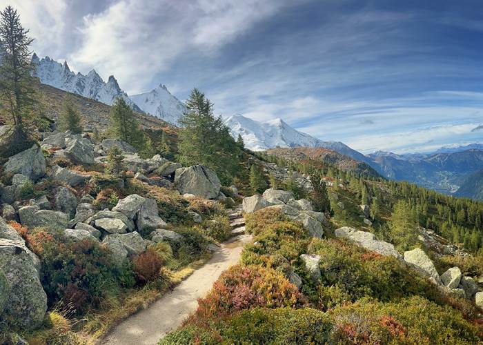
Autumn is undoubtedly the most peaceful season to explore the Chamonix Valley on foot. From mid-September to the end of November, the forests are adorned with magnificent hues of gold, orange, and vibrant red, while the first snow-capped peaks contrast with the brightly colored larches. The softer, lower light enhances the landscapes and creates a unique atmosphere.
After the summer bustle, the trails regain their tranquility. It's the perfect time to fully enjoy the mountains, observe alpine wildlife more easily, and savor the silence of the wide-open spaces. Many hikes remain accessible, from walks in the valley bottoms to panoramic high-altitude routes, depending on the season's conditions.
In autumn, the days get shorter and the weather can change rapidly. It is essential to check the forecast before each outing, to pack warm clothing and good footwear, and to plan to return before nightfall. At the end of the season, the first snowfalls can make some high-altitude routes impassable.
To prepare for your hikes, feel free to consult the updated information from the Compagnie des Guides de Chamonix, La Chamoniarde (visit the website here) , as well as the many guides and maps available in our apartments.
To help you plan your autumn getaway, I've selected the most beautiful hikes in the Chamonix Valley and around Vallorcine (I've limited it to about 20 routes, but with very different levels of difficulty), along with my local tips for enjoying the most stunning panoramas and the vibrant colors of the season. You'll have a hard time choosing...🧡
Many cable cars are open until mid-September, and the main attractions are open until November 1st: the Aiguille du Midi, the Montenvers train, and Le Brévent. The Flégère cable car usually opens for the All Saints' Day holidays (to be confirmed in 2026), so Lac Blanc is easily accessible with children.
Don't forget to check out my article dedicated to activities in the Chamonix valley (and surroundings): I present HERE: the 20 best activities with my local tips!
By staying in Vallorcine in my apartments , you can fully enjoy the magic of autumn. Surrounded by larch forests and unspoiled mountains, the village offers an exceptional setting for hiking away from the crowds and admiring one of the most beautiful color palettes in the Alps.
Vallorcine - Argentière - Swiss border area:
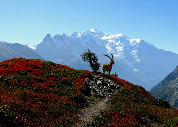
- Lac Blanc 🧡🧡🧡
Lac Blanc is the iconic hike of the Chamonix Valley. Its exceptional panorama of the Mont Blanc massif and its reflections in the lake's waters make it one of the most photographed sites in the Alps. A must-do for any first-time visit to the valley.
I recommend leaving early to avoid the crowds (in July/August).
There are many variations, but I much prefer starting at the Col des Montets. You'll be in ibex country.
Difficulty level: Intermediate (Flégère cable car) to difficult depending on the variations
Distance: 7 km
Duration: 4 to 6 hours
Elevation gain: 500 m to 1200 m
Altitude: 2,352 m
- Chéserys Lakes 🧡🧡🧡
Located just below Lac Blanc, the Lacs des Chéserys offer an enchanting setting with several small high-altitude lakes surrounded by alpine meadows. Numerous routes are possible. I recommend starting from the Col des Montets! It's common to see ibex; I love this hike.
Difficulty level: Intermediate (Flégère cable car) to difficult
Distance: 6 km
Duration: 3 to 5 hours
Elevation gain: 450 m to 1000 m
Altitude: 2,211 m
- The Aiguillette d'Argentière ⭐
The trail starts near the Trélechamp-le-Haut car park. It passes along the side of a large slab of rock, then continues to Plan de la Grange. Entering a beautiful larch forest, it climbs diagonally to 1710m. You are now in the Aiguilles Rouges nature reserve (dogs prohibited), and with luck you might spot some ibex.
Difficulty level: Intermediate
Distance : 8 km
Round trip duration: 3 hours
Elevation gain/loss: +500 m / -500 m
Altitude: from 1420 m to 1900 m
- Les Chalets de Loriaz – Vallorcine 🧡🧡🧡
An unmissable hike in the Chamonix valley in all seasons
Starting from Vallorcine, this magnificent loop takes you to the alpine chalets of Loriaz (2020 m), nestled in the heart of the Aiguilles Rouges massif. Start: Couteray, return: Couteray
Upon arrival? A breathtaking panorama facing the Mont Blanc massif… a view you never tire of. A delicious break at the Loriaz refuge (remember to check opening times) is the perfect reward after the effort. I highly recommend it!
Difficulty level: Difficult
Round trip duration: 4 hours (depending on snow conditions and difficulty level)
Elevation gain: +700 m
Altitude: from 1200 m to 1900 m
- La Pierre à Bérard Vallorcine👍
A very pleasant hike along the Eau de Bérard, partly through larch woods, bordering the Vallon de Bérard Nature Reserve. At the end: a mountain refuge with food available. The trail starts at the hamlet of Le Buet in Vallorcine and leads to the Refuge de la Pierre à Bérard (highly recommended!).
Beware of the first snows!
Difficulty level: Difficult
Distance: 10 km
Round trip duration: 3 hours 30 minutes
Elevation gain/loss: +600 m / -600 m
Altitude: from 1300 m to 1900 m
- Granges Vallorcine Loop 🏔️
A good alternative if you don't have the energy to go to the Loriaz chalets. My personal favorite, with a magnificent view of the Aiguille Verte from the hamlet of Les Granges. Departure from Couteray towards the hamlet of Les Granges, return via the Bérard valley/Bérard waterfall.
Difficulty level: Easy (valley bottom)
Distance: 5 km
One-way journey time: 3 hours
Elevation gain: +200 m
Altitude: 1300 meters to 1450 meters
- Aiguillette des Posettes and Tête de Balme 🧡🧡🧡
This panoramic hike is one of the most beautiful accessible from Vallorcine. From its summit, the 360° view extends to Mont Blanc, the Aiguilles Rouges, the Buet, and the Swiss mountains. A true natural viewpoint. In summer, access is via the cable cars from Le Tour or Vallorcine.
The autumn colours are incredible, it's turning red ❤️
Difficulty level: Intermediate (starting from the top of the gondolas) to difficult
Distance: 6 km to 8 km
Duration: 3 to 4 hours
Elevation gain: 450 m to 650 m
Altitude: 2,201 m
- Stroll around the main town of Vallorcine ⛪
A lovely historical walk to immerse yourself in the heart of the hamlets of Vallorcine. Loop from the church of Vallorcine to the hamlet of Buet following the old stagecoach road (numerous paths to discover along the railway or the river).
Difficulty level: easy (valley bottom)
Distance: 4.5 km
One-way journey time: 2 hours
Elevation gain: +90 m
Altitude: 1300 meters
- Bérard Waterfall ⭐
A lovely walk starting from the hamlet of Buet, then an impressive Bérard waterfall, well-equipped with a footbridge, a colorful refreshment stand with homemade products and a curious cave at Farinet, return via Le Couteray.
Take a break at the refreshment stand, it's excellent!
Difficulty level: Easy
Distance: 4 km
Duration: 1 hour 30 minutes to 2 hours
Elevation gain: 250 m
Altitude: 1,550 m
- Small south-facing balcony: Argentière-Les Tines 🏔️
This trail runs through the Chamonix valley, it allows you to reach Argentière aux Tines and offers beautiful views of the valley and the Mont Blanc range at every moment.
Return possible via the Mont Blanc Express train
Difficulty level: easy (valley bottom)
Distance: 4 km
One-way journey time: 1 hour 15 minutes
Elevation gain/loss: +90 m / -200 m
Altitude: from 1247 m to 1290 m
- The Péclerey Mountain ❤️
I absolutely loved this magnificent, little-known hike, with views of the Mont Blanc massif and the Tour glacier. The hike starts from the hamlet of Le Planet and returns via Le Tour.
Difficulty level: Intermediate
Distance: 8 km
Duration: 3 hours 30 minutes
Elevation gain: 600 m
Altitude: 2000 m (max)
- Lake Émosson: Dinosaur tracks 💙
Located in Switzerland, a few kilometers from Vallorcine, Lake Émosson captivates visitors with its turquoise waters and magnificent surroundings. This excursion also offers the opportunity to discover the famous dinosaur footprints, over 240 million years old.
A site not to be missed! I recommend it (possibility of zip-lining at the Emosson dam).
Condition to be validated in the autumn.
Difficulty level: Intermediate
Distance: 10 km
Duration: 5 hours
Elevation gain: 500 m
Altitude: 2400 m
- The Trient Bisse 👨👩👧👦
An easy and beautiful hike for the whole family. Head towards Martigny in Switzerland until you reach the Col de la Forclaz parking area. Take the Bisse de Trient path to the Trient Glacier refreshment stand.
A lovely, easy family hike.
Difficulty level: easy
Distance: 6.5 km
Round trip duration: 2 hours
Elevation gain: +100 m
Altitude: 1550 m
Chamonix area:
- The Montenvers - Plan de l'Aiguille crossing 🧡🧡🧡
A must-do in the autumn (check conditions).
A classic hike in the valley, without any particular difficulties. Take the little train from Montenvers with a ticket valid for the descent via the Plan de l'Aiguille cable car (I personally prefer going in that direction). This hike is a must for me; a stop at the Montenvers refuge is essential, and the passage by the Signal Forbes is breathtaking. Magnificent views of the Mont Blanc massif towards Plan de l'Aiguille. A superb refreshment stand at the Plan de l'Aiguille refuge serves delicious blueberry tarts.
Difficulty level: Intermediate
Distance: 6-7 km
Duration: 3 hours
Elevation gain: 500 m
Altitude: 2000 m
- Le Brévent 🚠
Directly overlooking Chamonix, the Brévent is considered one of the most beautiful viewpoints in the Mont Blanc massif. From its summit, the panorama of the glaciers and the great peaks is simply spectacular. Several variations are possible, with return routes via Les Houches.
Difficulty level: Intermediate to difficult
Distance: 8 km
Duration: 4 to 5 hours
Elevation gain: 600 m
Altitude: 2,525 m
- Forbes Signal 🚋
Accessible from the Montenvers train, this easy hike offers magnificent views of the Mer de Glace glacier, the Drus peaks, and the Grandes Jorasses mountains. An excellent choice for enjoying a breathtaking panorama without excessive effort.
Difficulty level: Easy
Distance: 5 km
Duration: 2 hours 30 minutes
Elevation gain: 250 m
Altitude: 2,198 m
- Small southern balcony: Les Tines – Les Gaillands Chamonix
Panoramic balcony with minimal elevation gain. Numerous viewpoints overlooking the Mont Blanc massif. Return possible via the Mont Blanc Express train – Pélerins station.
Difficulty level: easy (valley bottom)
Distance: 8 km
One-way journey time: 2 hours 45 minutes
Elevation gain/loss: +190 m / -250 m
Altitude: from 1080 m to 1270 m
- The Hat Chalet 👌
Viewpoint overlooking the Mer de Glace, the Arveyron Gorges, the Aiguilles and the Chamonix Valley. Departure from the SNCF train station in Les Tines (other routes are possible from Les Bois or Le Lavancher).
A wonderful and delightful time at the Chapeau refreshment stand (open depending on the weather), I highly recommend it!
Difficulty level: Medium (balcony)
Distance: 5 km
Round trip duration: 2 hours 30 minutes
Elevation gain/loss: +500 m / -500 m
Altitude: from 1050 m to 1600 m
- Rochers des Mottets 👍
Stunning viewpoint overlooking the Aiguilles des Drus. Amazing site of red rocks. View of the Mer de Glace glacier. Starting point: Les Bois hamlet (or Chamonix Les Planards).
Superb refreshment stand with light meals: I recommend it!
Difficulty level: Medium (balcony)
Distance: 8 km
Round trip duration: 3 hours
Elevation gain/loss: +600 m / -600 m
Altitude: from 1050 m to 1650 m
Houches/Servoz area:
- The chalets of Charousse, Les Houches 🏚️
Magnificent views of Mont Blanc and a grand setting at the Charousse chalets.
Starting point: Prarion Les Chavants car park, right next to the pretty Lac des Chavants, then head towards the Charousse chalets. This can be an out-and-back walk, or a loop.
A real gem and a site steeped in history, an easy walk to do with the family!
Difficulty level: Easy
Distance: 4 km
Round trip duration: 1 hour 45 minutes
Elevation gain: +200
Altitude: from 1,000 m to 1,200 m
- Green Lake 💚
An easy hike leading to Lac Vert, a magical spot accessible from Servoz. The forest trail offers a pleasant walk with the option to circle the lake or extend the hike to superb viewpoints such as Plaine-Joux.
Difficulty level: easy (valley bottom)
Distance: 3.8 km
Round trip duration: 1 hour 30 minutes
Elevation gain/loss: +200 m / -200 m
Altitude: from 1082 m to 1270 m
Chez Charles**** | Vallorcine Viachamonix
One Visit Is Never Enough
Rental of 4-star apartments in Vallorcine, in a residence with an indoor pool, sauna, steam room, and Jacuzzi – gondola lift 50m away