


Top Hikes in Chamonix Spring
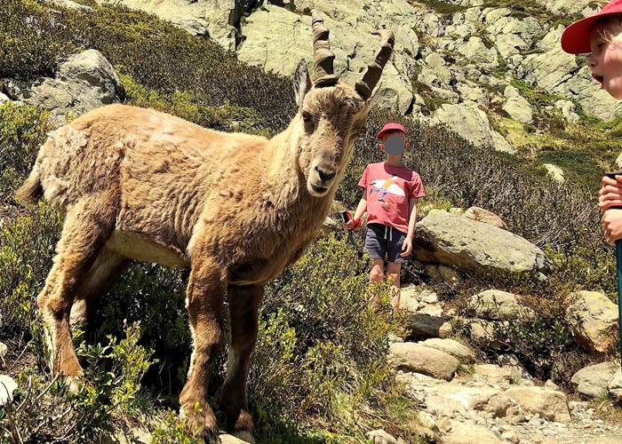
Magical hike with my children
Top spring hikes in Chamonix
As the snow begins to melt and nature awakens, the Chamonix Valley reveals a unique face. Spring is a magical season, with snow-capped peaks and verdant valleys. This time of year is ideal for enjoying peaceful hikes in a soft, luminous atmosphere, with the opportunity to observe alpine wildlife up close.
You need to adapt your outings according to the snow cover and weather conditions because between mid-March and mid-June the playing field changes.
It is particularly advisable to favour valley bottom hikes in early spring.
In early spring you can still go snowshoeing using ski lifts (Houches, Flégère and Balme) refer to my article "Top snowshoes Chamonix".
Check the conditions with the High Mountain Office in Chamonix: http://www.chamoniarde.com/.
More information can be found in our numerous guides available in our apartments.
To help you organize your spring break, I have selected 15 superb hikes/walks to do in Chamonix and around Vallorcine , with my local tips to make the most of your stay.
By staying in Vallorcine, you can enjoy the peace and quiet of nature while remaining in close proximity to the must-see attractions of the Chamonix valley.
- Granges Loop:
My favorite route, with a magnificent view of the Aiguille Verte at the hamlet of Les Granges. Departure from Couteray towards the hamlet of Les Granges, return via the Bérard valley/Bérard waterfall.
Difficulty level: Medium (valley bottom)
Distance: 5 km
One-way journey time: 3 hours
Elevation gain: +200 m
Altitude: 1300 meters to 1450 meters
- Loop around the Bérard waterfall:
A lovely walk starting from the hamlet of Le Buet, then an impressive Bérard waterfall, well-maintained with a footbridge, a colorful refreshment stand with homemade products, and a curious Farinet cave; return via Le Couteray.
Difficulty level: easy
Distance: 3.5 km
One-way journey time: 1 hour 30 minutes
Elevation gain: +200 m
Altitude: 1300 meters to 1450 meters
- Walk around the main town of Vallorcine:
A lovely historical walk to immerse yourself in the heart of the hamlets of Vallorcine. Loop from the church of Vallorcine to the hamlet of Buet following the old stagecoach road (numerous paths to discover along the railway or the river).
Difficulty level: easy (valley bottom)
Distance: 4.5 km
One-way journey time: 2 hours
Elevation gain: +90 m
Altitude: 1300 meters
- Small south-facing balcony: Argentière-Les Tines
This trail runs through the Chamonix valley, it allows you to reach Argentière aux Tines and offers beautiful views of the valley and the Mont Blanc range at every moment.
Return possible via the Mont Blanc Express train
Difficulty level: easy (valley bottom)
Distance: 3.8 km
One-way journey time: 1 hour 15 minutes
Elevation gain/loss: +90 m / -200 m
Altitude: from 1247 m to 1290 m
- Small southern balcony: Les Tines – Les Gaillands Chamonix
Panoramic balcony with minimal elevation gain. Numerous viewpoints overlooking the Mont Blanc massif. Return possible via the Mont Blanc Express train – Pélerins station.
Difficulty level: easy (valley bottom)
Distance: 8 km
One-way journey time: 2:45
Elevation gain/loss: +190 m / -250 m
Altitude: from 1080 m to 1270 m
- The Chalets of Loriaz – Vallorcine:
An unmissable hike in the Chamonix valley in all seasons
Starting from Vallorcine, this magnificent loop takes you to the alpine chalets of Loriaz (2020 m), nestled in the heart of the Aiguilles Rouges massif.
Departure: Couteray. Return to Couteray until May (late spring return to Couteray possible if there is no snow).
Upon arrival? A breathtaking panorama facing the Mont Blanc massif… a view you never tire of. A delicious break at the Loriaz refuge (remember to check opening times) is the perfect reward after the effort. Highly recommended.
Difficulty level: Difficult
Round trip duration: 4 hours (depending on snow conditions and difficulty level)
Elevation gain: +700 m
Altitude: from 1200 m to 1900 m
- The Hat Chalet:
Viewpoint overlooking the Mer de Glace, the Arveyron Gorges, the Aiguilles and the Chamonix Valley. Departure from the SNCF train station in Les Tines (other routes are possible from Les Bois or Le Lavancher).
A wonderful and delightful time at the Chapeau refreshment stand (open depending on the weather), I highly recommend it!
Difficulty level: Medium (balcony)
Distance: 5.3 km
Round trip duration: 2 hours 40 minutes
Elevation gain/loss: +500 m / -500 m
Altitude: from 1050 m to 1600 m
The chalets of Charousse, Les Houches:
Magnificent views of Mont Blanc and a grand setting at the Charousse chalets.
Starting point: Prarion Les Chavants car park, right next to the pretty Lac des Chavants, then head towards the Charousse chalets. This can be an out-and-back walk, or a loop.
Difficulty level: Easy
Distance: 4 km
Round trip duration: 1 hour 45 minutes
Elevation gain: +200
Altitude: from 1,000 m to 1,200 m
- Green Lake:
An easy hike leading to Lac Vert, a magical spot accessible from Servoz. The forest trail offers a pleasant walk with the option to circle the lake or extend the hike to superb viewpoints such as Plaine-Joux.
Difficulty level: easy (valley bottom)
Distance: 3.8 km
Round trip duration: 1 hour 30 minutes
Elevation gain/loss: +200 m / -200 m
Altitude: from 1082 m to 1270 m
- The Trient Bisse:
An easy and beautiful hike for the whole family. Head towards Martigny in Switzerland until you reach the parking area at the Col de la Forclaz. Take the path along the Bisse de Trient, until you reach the refreshment stand at the Trient Glacier.
Difficulty level: easy
Distance: 6.5 km
Round trip duration: 2 hours
Elevation gain: +100 m
Altitude: 1550 m
- Rochers des Mottets (from May 1st, depending on conditions):
Stunning viewpoint overlooking the Aiguilles des Drus. Amazing site of red rocks. View of the Mer de Glace glacier. Starting point: Les Bois hamlet (or Chamonix Les Planards).
Superb refreshment stand with light meals: I recommend it!
Difficulty level: Medium (balcony)
Distance: 8 km
Round trip duration: 3 hours
Elevation gain/loss: +600 m / -600 m
Altitude: from 1050 m to 1650 m
- L'Aiguillette d'Argentières (from mid-May depending on conditions):
The trail starts near the Trélechamp-le-Haut car park. It passes along the side of a large slab of rock, then to the Plan de la Grange. Entering a beautiful larch forest, it climbs diagonally to 1710m. You are now in the Aiguilles Rouges nature reserve (dogs prohibited), and with luck you might spot some ibex.
Difficulty level: Medium
Distance: 8 km
Round trip duration: 3 hours
Elevation gain/loss: +500 m / -500 m
Altitude: from 1420 m to 1900 m
- The Chezerys Lakes from the Col des Montets (from mid-May depending on conditions):
A must-do. It's still too early to go all the way to Lac Blanc, which is usually accessible from the beginning of July, but this hike from the Col des Montets to the Chezerys lakes is well worth the trip in the spring. It's not uncommon to spot ibex.
At Tête au Vents, I recommend returning via the Bois de Bagnolet to Argentières (because the return via the Aiguillette d'Argentières involves tricky sections with ladders). Then from Argentières, return to the Col des Montets.
Difficulty level: Difficult
Distance: 10 km
Loop duration: 5 hours
Elevation gain/loss: +700 m / -700 m
Altitude: from 1400 m to 2000 m
- La Pierre à Bérard (from June 1st, subject to conditions):
A very pleasant hike along the Eau de Bérard river, partly through larch woods, bordering the Vallon de Bérard Nature Reserve. At the end: a mountain refuge with food service. The trail starts at the hamlet of Le Buet in Vallorcine and leads to the Refuge de la Pierre à Bérard.
Difficulty level: Difficult
Distance: 10.4 km
Round trip duration: 3 hours 30 minutes
Elevation gain/loss: +600 m / -600 m
Altitude: from 1300 m to 1900 m
Chez Charles****'s | Vallorcine Viachamonix
Apartment rentals**** in Vallorcine in a residence with indoor pool, sauna and hammam, at the Les Portes Du Mont Blanc Resort